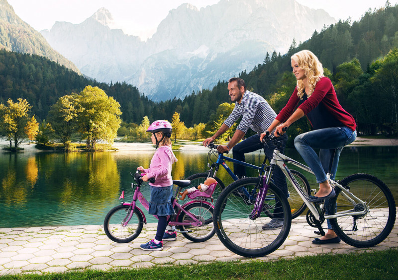
Cycling in Kranjska Gora
Cycling
The varied landscape of the Upper Sava Valley beckons with its well-marked bicycle paths. Choose easier family tours or go on a more demanding trip into the heart of the Alpine valleys. In both cases you will be richly rewarded.
Cycling for Everyone
An Active Holiday
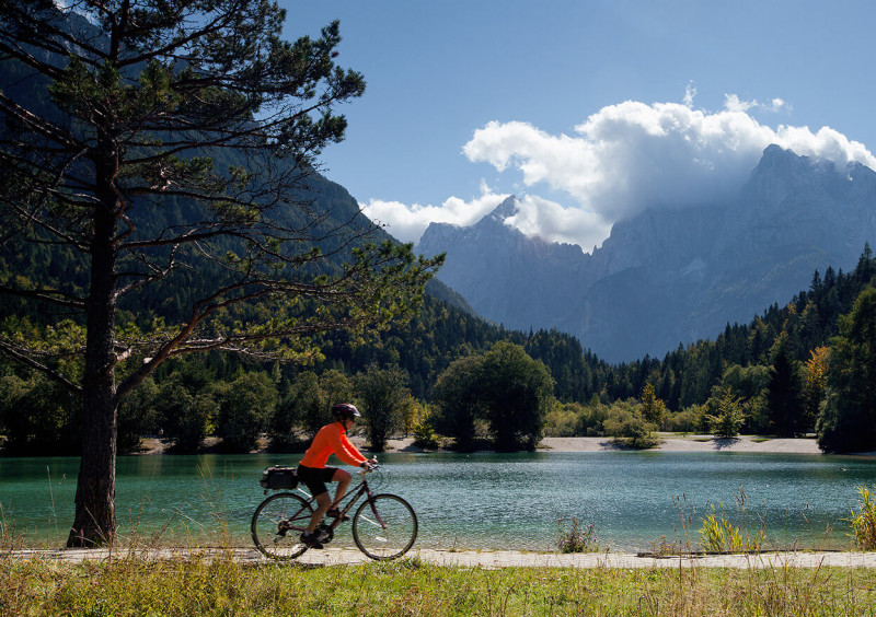
Cycling is probably the most fun way to explore the beautiful nature in Kranjska Gora and its surroundings. A safe cycling route, which is also suitable for family trips, leads through Kranjska Gora and onwards across the borders with Italy and Austria. The terrain in the valley is very diverse so beginner bicyclists, as well as those who want a bigger challenge, can easily find the most suitable routes. We want you to set off well-equipped so we prepared a helpful map with 200 km of marked cycling routes. You can get it in all tourist information centres in Kranjska Gora, Mojstrana and Rateče.
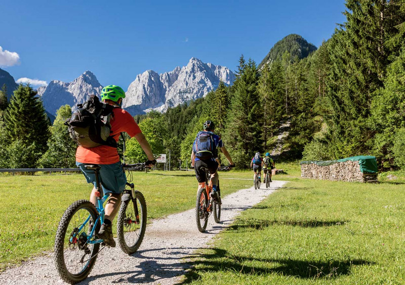
Mountain Biking
To the Tops, among the Woods
Many marked mountain trails are intended for beginners and experienced bicyclists. Get sweaty and soak up the sun on the pleasantly rounded peaks of the Karawanks. On the cycling route of the three countries, starting at the tri-border with Austria and Italy, you can rush through the Radovna valley to Bled. While riding on the well-maintained trails, you will be able to admire nature in its most authentic form. For some extra adrenaline and nature discovery, bicycle on one of the marked single-tracks which you will find around Kranjska Gora. Don’t be fooled by some of their names, they are not as innocent as you might expect when you hear the names Kinder Surprise or Robe Twist.
Sources:
http://www.mojstrana.com/sl/
https://kranjska-gora.si/
https://www.hribi.net/
![]()
BIKING SUGGESTIONS
From the hotel, we head past the ski slopes towards Rateče. Soon we join the cycle path, which gradually climbs. In Podkoren, we drive past the venue for the Alpine Skiing World Cup and continue past the cable cars. On the right side, we will notice a sign for the Zelenci Nature Reserve, where a short stop is made. The route passes Rateče and we take the 3rd exit at the roundabout to Planica. A slightly steeper road leads us directly to the Planica Nordic Center, but if you wish, you can go down the Planica zipline for an additional fee.
The difficulty of the route: 1
Starting point: Kranjska Gora (810 ASL)
Midpoint 1: Podkoren (836 ASL)
Midpoint 2: Rateče (866 ASL)
Finish: Planica (926 ASL)
Distance: 16.000 m
The bike tour starts at the Kompas Hotel and continues east along the bike path. You will cycle through the villages of Gozd Martuljek, Belca, and Mojstrana. The bike path follows the path of the former railway and after 20 kilometers you will reach Jesenice. In Mojstrana, you can make a short stop at the Slovenian Mountain Museum.
The difficulty of the route: 2
Starting point: Kranjska Gora (810 ASL)
Midpoint 1: Gozd Martuljek (744 ASL)
Midpoint 2: Mojstrana (651 ASL)
Finish: Jesenice (571 ASL)
Distance: 20.000 m (in one direction)
The Vršič mountain pass lies at 1,611 meters above sea level, between the beautiful peaks of the Julian Alps. The route is accessible via a regional road, which is 12 kilometers long and quite steep. The start is at the hotel, where you continue through Kranjska Gora to Lake Jasna, where you continue along the road to the Vršič pass. There are a few huts on the way where you can stop and have a short stopover. After 8 kilometers of the route, you will reach the Russian Chapel, which is a memorial to fallen Russian soldiers in the First World War. You still have a good 4 kilometers to go to the top of the Vršič Pass.
Be especially careful when returning to Kranjska Gora and adjust your speed when driving down the hill.
The difficulty of the route:
Starting point: Kranjska Gora (810 ASL)
Midpoint 1: Junction towards Brda (825 ASL)
Midpoint 2: Lake Jasna (850 ASL)
Midpoint 3: Russian Chapel (1.158 ASL)
Finish: Vršič pass (1.618 ASL)
Distance: 12.000 m (Kranjska Gora – Vršič)
From the hotel, head towards Lake Jasna, where you will continue your journey in the direction of the Vršič pass. At the Erika bridge, turn slightly left and cycle along the unpaved path, along the Pišnica river, all the way to the cottage in Krnica. From there you will have a very nice view of the peaks of the Julian Alps.
The difficulty of the route: 2
Starting point: Kranjska Gora (810 ASL)
Midpoint: Bridge Erika (869 ASL)
Finish: Hut in Krnica (1.117 ASL)
Distance: 14.000 m
From the hotel, head east along the bike path, along the Sava River, past Martuljk, and turn right at Mojstrana. From the Slovenian Mountaineering Museum, the route continues towards the Peričnik waterfall and further to the Vrata valley. From here you will observe the 800-meter-high Triglav North Wall. The route ends at Aljaževa koča, where you can treat yourself to local delicacies.
The difficulty of the route: 2
Starting point: Kranjska Gora (810 ASL)
Midpoint 1: Gozd Martuljek (744 ASL)
Midpoint 2: Slap Peričnik (751 ASL)
Finish: Aljaževa koča (1.010 ASL)
Distance: 24.000 m (Kranjska Gora – Aljaževa Koča)
From the hotel, we head toward the Slovenian Alpine Museum in Mojstrana. From there we continue towards the Vrata valley and turn left after 300 meters. We drive over the bridge and follow the road up a short macadam climb that joins the main road leading to Radovna. Here we turn right and start climbing up to Kosmačev preval. There we turn right onto the macadam road for the Kot valley. We follow the path all the way to the intersection, where a short steep climb awaits us. We continue along the road to Lengarjev rovt and descend on the same road to Kosmačev preval. Turn right there and follow the signs for Krma.
The difficulty of the route: 2
Starting point: Kranjska Gora (810 ASL)
Midpoint 1: Gozd Martuljek (744 ASL)
Midpoint 2: Lengarjev rovt (954 ASL)
Finish: Kovinarska koča v Krmi (865 ASL)
Distance: 22.200 metrov (Kranjska Gora – Krma
From the hotel, we head west to Rateče. We drive along the Alpe Adria route, which leads us to Trbiž and further into Austria to Arnoldstein. The route follows the former railway and does not have steep climbs. After crossing the state border, you can turn left towards the Belopeška Lakes (Laghi di Fusine). There are many shops and a delicious bakery in Trbiž. We continue along the marked routes to Austria. You can go back the same way or contact the hotel to arrange a transfer for you.
The difficulty of the route: 2
Starting point: Kranjska Gora (810 ASL)
Midpoint 1: Rateče (910 ASL)
Midpoint 2: Trbiž Italy (750 ASL)
Midpoint 3: Arnoldstein Avstrija (578 ASL)
Distance: Kranjska Gora – Trbiž 20 km, Trbiž – Arnoldstein 22 km
One of the most scenic tours in the surroundings of Kranjska Gora with a beautiful view of the Julian Alps, which accompanies us throughout our journey. For this view, we first try to climb from Podkoren towards Korensko sedlo, where a little before it we turn right onto the forest road, which will lead us along the southern side of the western part of the Karavanski greben with a moderate slope. Due to the beautiful views of Julian Alps, which open up to us behind Brvogami, where the TV tower stands, as the forest thins out here, cycling will pass us by quickly. Throughout, we cross the slope eroded by ravines and observe the grassy slopes of the Kranjska Gora ski slopes, which climb toward the top of Vitranc. On Jureževa planina, there is a turnoff to the left for Vošca, which we can climb without a bicycle, as it is unsuitable for driving, and we also look at the Carinthian side. A similar view awaits us from Blekova Planina, where we can cycle and to which the left branch leads a little later, just before the end of our ascent. It ends in the Železnica valley, through which the Jerman stream flows, and we can follow it when descending into the valley. The descent is technically demanding and suitable for experienced cyclists with good equipment. For everyone else, it is better to go back the way you came.
The difficulty of the route: 3
Starting point: Kranjska Gora (810 ASL)
Midpoint 1: Crossroad by the former train station Podkoren (836 ASL)
Midpoint 2: Poljana (1.029 ASL)
Finish: Železnica (1.519 ASL)
Distance: 15.700 m (Kranjska Gora – Železnica)
Above Gozd-Martuljk, on the wooded slopes of Karavanke, a good 200 meters above the Sava Dolinka valley, a grassy platform opens up on which the homesteads of Srednji Vrh are scattered. Glaciers have created this shelf, from which one of the most beautiful views of our mountains opens, on the Martuljk or Špik group.
From Kranjska Gora, we follow the bicycle route to Gozd Martulj, where we turn left and then climb towards Srednji vrh on a narrow asphalted road that barely allows two cars to meet. Sharp bends overcome an almost vertical bank, and in the depths, we can hear the murmur of the waterfalls of the Jerman stream, which flows from Železnica down the valley past Srednji Vrh into the Sava. After a steep climb, we are rewarded with one of the most beautiful views of the Martuljk group of mountains, which rise into the sky at the opposite end of the valley.
Due to the exceptional view, it is best to choose a clear and sunny day, as this is the only way to see all the beauty of the mountain scenery.
If we haven't climbed enough yet and would like to get some fresh air, we can try our best to reach Jurež's homestead, which lies alone at the end of the carriageway. The return is by the same route.
The difficulty of the route:
Starting route: Kranjska Gora (810 ASL)
Midpoint: Mali Špik Gozd Martuljek (744 ASL)
Finish: Farm Jurež (1.028 ASL)
Distance: 8.200 m (Kranjska Gora – Farm Jurež)
We already know how to get to Rateče, as the route of the former railway, which takes us almost to the border crossing, is an ideal cycling route. After crossing the border, after just under a kilometer, turn left from the main road at the first fork and drive to the intersection, where the signpost shows the direction to the Belopeška Lakes (Laghi di Fusine). We continue to the next fork, where the left path leads back to the border, and we continue straight to the right and cycle through the forest to the village of Scicchizza, where we join the main asphalt road that leads to the Belopeška Lakes.
There we turn left, where a steep slope leads to the first lake. From there we descend to the second lake and then continue along the forest road to the lock. From here on, the sports part of cycling begins. We continue the path straight (on the left is for hikers and on the right is the path to Mangart, which is not for cyclists).
Soon we reach a concrete slope, which lets us know that it will be steep. Due to the gushing water, which during downpours on steep parts can wash away parts of the path, there are quite a few such concrete sections to the destination of our path, the Zacchi hut. This is where our fitness will be tested and if we can make it all the way up to the hut without stopping or getting off the bike then we are really good.
A hut awaits us at the top, where we can rest before returning back. The descent can be made along the same route or along a well-marked trail for hikers.
Watch out! It is intended for hikers, and let's take this into account when meeting them. The serpentine path is paved and well-maintained at almost all corners, but it is still very demanding.
The difficulty of the route:
Starting point: Kranjska Gora (810 ASL)
Midpoint 1: Crossroad by the formal railway station Podkoren (836 ASL)
Midpoint 2: Crossroad by the formal railway station Rateče (862 ASL)
Midpoint 3: Junction to Belopeška lakes (Laghi di fusine) (1.216 ASL)
Finish: Hut Zacchi (1.380 ASL)
Distance: 17.000 m (Kranjska Gora – Koča Zacchi)
We leave the hotel towards Mojstrana. From here, the route continues along a well-maintained forest road with an initial easy ascent. The path gets steeper and steeper, and there is no view, as we drive through the forest, but a beautiful view awaits us at the top. We continue along the path and reach the Dovška Rožca alpine pasture. The last 100-150 meters are very tiring, as it is a very steep climb. At the top, you can also go on foot to Dovška baba, which is located 200 meters higher.
Warning: the path is steep and sandy and it has some slippery sections, so please be careful.
The difficulty of the route: 3
Starting point: Kranjska Gora (810 ASL)
Midpoint 1: Mali Špik Gozd Martuljek (744 ASL)
Midpoint 2: Junction towards Ravne (1.070 ASL)
Finish: Alpine pasture Dovška Rožca (1.640 ASL)
Distance: 22.500 m (Kranjska Gora – Dovška Rožca)
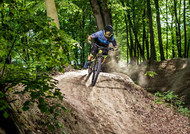
Cycling park
A Rush of Adrenaline
For those looking for adrenaline and sharp turns, a cycling park has been set up in Kranjska Gora. It inspires beginners and challenges professionals. Test your skills and bike on table tops, jumps, gaps and other objects. Before the wild downhill ride, take the chairlift up the Vitranc slope.
FOR ADRENALINE SEEKERS
Kranjska Gora offers a bicycle park for all adrenaline seekers, which offers the pleasures of mountain freestyle and an adrenaline-filled descent through tables, jumps, swings, and other obstacles. Take the Vitranc 1 cable car up to the entrance to the bike park and experience a wild descent.
Freeride course
This year we will add new ones to the already established course with more than 40 artificial obstacles. Even last year's obstacles, at least some of them, will be slightly modified, so that they will allow for the safest possible driving and landings after landings with a ski jump. There is also a training ground in the plan, where the less experienced will be able to learn the basics of freeriding without any worries.
The focus will be on obstacles suitable for learning cycling skills, which will be made in several difficulty levels. They will be made in such a way that everyone can try them out and come to the most demanding ones. A new section of the forest trail will also be opened, on which a new "north shore" section will grow, and the existing one will be supplemented with new elements. The freeride track is supposed to become a kind of "children's playground" for cycling enthusiasts.
DH course
With its almost two kilometers and about a good 350 m difference in height, the DH program covered last year for the Cup of Slovenia made it possible to ride fast for downhill addicts. A few more variants of this track will be made for this season, which will increase the technical difficulty of the same track. We will do our best to ensure that the course will satisfy as wide a range of cyclists as possible. We will increase its wooded technical part, add a new version, also through the forest, and make some long jumps on the open sections, which will spice up the quick descent into the valley. It will be able to be combined with the freeride course on almost the entire duty.
To the start of the descent, we ascend along the asphalt road through the settlement of houses by Lake Jasna, which continues into the macadam road. The descent is categorized as very demanding and starts just before the end of the gravel road.
The descent begins on easier terrain, where steep sections with technical parts begin after the transition to the ridge part of the descent. After the transition from the ridge to the medium-demanding part of the descent, a part of the descent opens up to us with various "park" elements that enrich the fun part of the descent. The descent ends when we cross the stream and join the macadam road, on which we descend to the bicycle path and further left to the center of Kranjska Gora.
The difficulty of the descent: 3
We recommend a good mountain bike.
Total distance of the descent: 1.400 m
TOPOGRAPHIC MAP OF SLOVENIA
For the easier organization of your travel, scan the QR code and find a topographic map of Slovenia!

GPS INSTRUCTIONS
Scan the code and insert the route for GPS instructions.


Long Distance Cycling
For the Most Persistent
Circumnavigate the Julian Alps by bicycle. The circular cycling route leads from Kranjska Gora through Bled, Bohinj, Tolmin, Kobarid, Bovec, and over the Vršič pass back to Kranjska Gora. The whole route is 232 km long. We recommend that you cycle it in five stages or five days. On the way you have enough time to relax at your accommodation and prepare your body for a new day of cycling.